• Skip to main content
  • Skip to primary sidebar

Palouse-Clearwater Environmental Institute

“connecting people, place and community”

  • Learning
    • Palouse Roots
    • Nature Explorers
    • Community Education
    • School Programs
    • ENGAGE at Paradise Ridge
  • Serving
    • Volunteer
    • AmeriCorps Placement Program
      • Our AmeriCorps Members
      • Become an AmeriCorps Member!
        • Positions Available
      • Become a Sponsor
      • Forms and Important Dates for Members & Sponsors
    • Adopt-A-Stream Program
  • Restoring
    • Projects
    • Services
    • John Crock Learning Nursery
    • Plants
    • Useful Links
  • Living
    • Sustainable Living Projects at PCEI
    • Community Resources
    • The Plate Project
  • Nature Center
    • Nancy Taylor Stage and Pavilion
    • John Crock Learning Nursery
    • Thomas O. Brown Learning Greenhouse
    • The LaFortune “Groover”
    • Solar Power
    • Pump Track
    • NestWatch at the PCEI Nature Center
  • Rose Creek
    • Birding at Rose Creek
  • Events
    • See all events
    • Volunteering
    • Sustainability Series
      • May 7 — The Art of Wisescaping
      • June 11 — EcoHeroes!
    • May 7, 14 and 18: Magic Month Bird Walks
  • Join/Donate
  • About PCEI
    • Mission & Goals
    • Our People
    • Job Openings
    • Our History
    • Our Funders
    • Our Newsletter
    • Awards and Recognition
    • Contact Us

South Fork Palouse River Riparian Enhancement Project – Howard Property

Watershed: Palouse River
Stream Name: South Fork Palouse River
Date Established: 07/30/2005
Project Status: Complete, maintenance and monitoring ongoing

Overview

Funding Agency: Department of Environmental Quality (DEQ); Private Donations

Project Location: Latitude: 46.7586 N, Longitude: 116.9063 W

Target Pollutants:

  • Sediment
  • Temperature
  • Nutrients
  • Bacteria

Waterbody Type(s): Intermittent

Hydrologic Unit Code: 17060108

Description

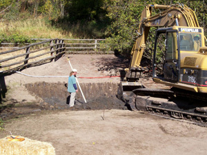
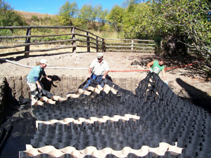
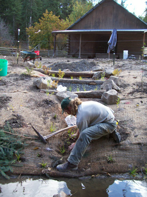
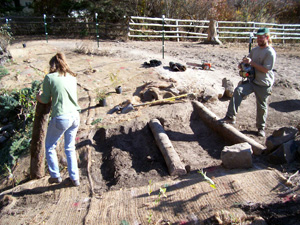
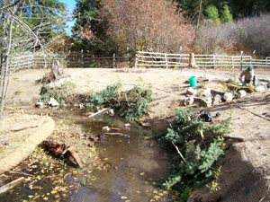
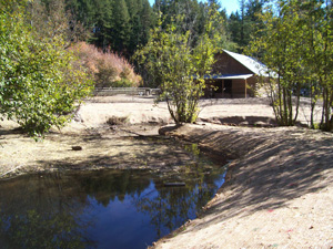
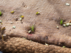
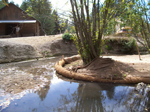
Located upstream from Robinson County Park on the South Fork Palouse River, the Howard project included the revegetation of approximately 10,867 square feet of a highly degraded reach of river that has been heavily grazed by horses. The downstream portion of the property was fenced and grazing was not permitted. Stream banks were resloped and erosion control fabric and soil wraps were installed. A brush revetment was also installed. Approximately 493 feet of stream bank was stabilized with woody, emergent and grass species in order to provide filtration of nutrients and sediment. The revegetation of the denuded stream banks will also help decrease stream temperatures by increasing shade.A stream crossing was installed using a GeoWeb® system. The stream crossing allows the horses to access the pasture on the opposite bank with minimal erosion. The stream crossing is approximately 24 X 20 feet and provides a durable, load support for the animals. The GeoWeb® system is a cost effective alternative to a hardened rock stream crossing and will control erosion, reducing impacts to water quality. The stream was fenced from the pasture using electric ribbon wiring.

In addition to the restoration work outlined under the 319 Nonpoint Source Subgrant, the landowner contracted PCEI to stabilize an additional 60 feet of unstable and eroding banks. A series of wetlands were also created to capture runoff from the adjacent hillside and redirect flows away from the eroding bank into a large wetland swale. An additional wetland was also created downstream adjacent to Robinson County Park to capture and filter runoff from an unnamed tributary.

Previous Conditions

Prior to restoration activities, livestock had full access to the creek. Grazing and impacts from overland flows from the barn roof and hillside contributed to eroding banks. Limited vegetation existed in this reach of river due to grazing pressures.

Photo History:

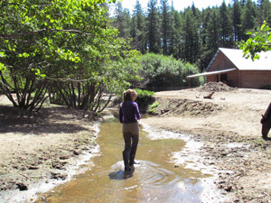
Tracy Brown and the Horses (July 2005): Prior to the installation of the GeoWeb® crossing, the horses had access to the creek in many places along this reach of river. The horses love to kick and splash in the river causing the channel to widen while also increasing sedimentation.

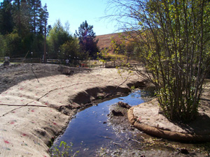
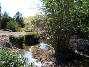
Photo Point V1 Downstream (August 2005): Photo Point V1 Downstream August 2005. The lack of vegetation and the severity of the bank instability.

Primary Sidebar

  • Restoring Home
  • Restoration Projects
    • Snake River Subbasin
      • Tammany Creek
        • Lucky Acres Arena
        • Best Management Practices Demonstration Project
    • Clearwater River Subbasin
      • Schaub Ranch
      • Lindsay Creek
        • Walton, Cowger and Neilson Property
      • Partridge Creek
        • Christianson Meadows
      • Potlatch River
        • Troy High School Restoration of Little Bear Creek
      • South Fork Clearwater River
        • Rylaarsdam Project
        • Kirtner Property
        • Native Vegetation Establishment Project: A Multiple Landowner Cooperative
    • Palouse River Subbasin
      • South Fork of the Palouse River
        • Fountain Property
        • Howard Property
        • Mill Road Bank Stabilization Project
        • Upper Watershed Project, Robinson County Park
        • Lower Watershed Project
      • Deep Creek
        • Adler Property
        • Espy Property
      • Flannigan Creek
        • Broyles and Reynolds Property
      • Paradise Creek
        • Bailey-Davis-Shipley
        • Berman Creekside Park
        • Big Draw
        • Bridge Street Park
        • Bridge Street: Residential
        • Brockington
        • Carol Ryrie Brink Nature Park
        • Chipman Trail
        • Dogwood Court
        • Fire Station
        • Forbes
        • Garton Hardened Rock Crossing
        • Good Samaritan Village
        • Hall and Mountain View
        • Harden Road
        • Heron’s Hideout
        • Joseph Street
        • Leffingwell-Reid
        • Lefors
        • Lightfield
        • Meadow Street #1
        • Meadow Street #2
        • Morton
        • Morton Extension
        • Moscow Wastewater Treatment Plant
        • Mountain View Park
        • Orchard
        • PCEI Nature Center
        • Remington
        • Renaissance Charter School
        • State Line
        • Streets
        • Styner Avenue
        • Sweet Avenue
        • Townsend Property
        • University of Idaho
        • White Avenue
        • Willard
  • Restoration Services
  • John Crock Learning Nursery
  • Plants
    • Plants for Wetland Restoration on the Palouse
    • Palouse Prairie Native Plants
    • Palouse Prairie Weeds
    • What is a Noxious Weed?
    • Sources for Native Plants
  • Useful Restoration Links
Our History

FAQ
Volunteer
Job Openings
Privacy Policy
Refund Policy

Mailing Address:

Palouse-Clearwater Environmental Institute

PO Box 8596

Moscow, ID 83843

Please do not mail donations or correspondence to our street address. USPS will not deliver them.

Contact Us:

Phone: (208) 882-1444

Email: info@pcei.org

Copyright © 2022 · Dynamik-Gen on Genesis Framework · WordPress · Log in