 Watershed: Palouse River
Stream Name: Paradise Creek
Date Established: 05/31/2001
Project Status: Complete, maintenance and monitoring ongoing
Overview
Funding Agency: Department of Environmental Quality
Project Location: Latitude: 46.7309 N, Longitude: -117.0383 W
Target Pollutants:
- Sediment
- Temperature
Waterbody Type(s): Intermittent
Hydrologic Unit Code: 17060108
Description
The restoration site is located on Paradise Creek in Moscow, Idaho on the University of Idaho campus at the state line with Washington. Reed canarygrass was the dominant vegetation and woody plants were largely absent. Streambanks were steep and eroding.
PCEI staff and volunteers stabilized and revegetated a 1,020 ft section of streambank. Earth-moving was completed by University of Idaho Farm Operations to reslope the streambanks. Banks were reconstructed with a 3:1 slope where possible and a 2:1 slope where space was limited. The resloped streambanks were seeded with native grasses and covered with erosion control fabric. Additionally, large chunks of concrete were removed from the channel during excavation. In especially erosion-prone sections, coir logs preplanted with emergent plants were installed at the toe of slopes.
Willow (Salix exigua, S. drummondia, S. mackenziana) and red-osier dogwood poles and dogwood fascines were planted on streambanks where initial plantings did not establish as well as desired. Weed control, watering, and maintenance tasks were performed. Invasive plants are a larger problem at the Washington state line than in the interior of the watershed because many plants are spreading from the west up the stream corridor. This increases maintenance and makes restoration plantings more difficult.
Previous Conditions
Streambanks along this segment of Paradise Creek were eroding due to a lack of woody vegetation, and the steepness of the banks. Reed canary grass formed a dense monoculture, whose shallow root mats promoted slumping of the streambank. Thus, the streambanks were frequently undercut during heavy storm events. The lack of trees or woody vegetation along this stream segment also allows the solar rays to heat the stream water, which decreases dissolved oxygen and is damaging to aquatic wildlife.
Photo History:
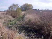
 State UI Before W (October 16, 2000): This photograph highlights the previously existing conditions of a landscape void of woody vegetation.
 State UI Before W (May 31, 2001): Taken from the same location as the above photograph, the streambank was resloped to either a 2:1 or a 3:1 slope. This was done to reduce erosion, to reconnect the floodplain, and to create an area to plant native vegetation.
 State Before E (October 16, 2000): Again similar site conditions just downstream of the previous reach. A dominant species is the poison hemlock, a noxious weed in Idaho.
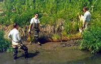
 State Restored E (June 6, 2001): This photograph was taken in the same location as the previous photograph. The excavator is in the process of resloping the streambank to minimize bank failure.
 State Coir Logs 1 (June 7, 2001): Coir logs were installed where excavation work could not be completed due to land use restrictions. These logs help to stabilize the toe of the slope.
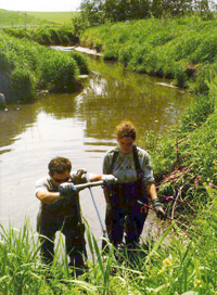
State Water Stinger (June 5, 2001): AmeriCorps*NCCC team members are using the water stinger to drill holes into the bank. Inserted into these holes will be live poles, which will root and grow into trees.