
Watershed: South Fork Clearwater River
Stream Name: South Fork Clearwater River
Date Established: 05/01/2010
Project Status: Active
Overview
Funding Agency: Department of Environmental Quality (DEQ)
Project Location: Latitude: 46.027428 N Longitude: 116.079397 W
Target Pollutants:
- Sediment
- Temperature
- Nutrients
- Bacteria
Waterbody Type(s): River
Hydrologic Unit Code: 17060305
Directions to Kirtner Site from Grangeville: (landowner permission to access is required)
Head East on ID 13/W Main Street toward N Hall Street. Continue to follow ID Highway 13 down the Harpster Grade. Take a sharp right onto Highway 14. Travel on Highway 14 upriver along the South Fork Clearwater River approximately 3 miles. There is an ITD pullout on the left, where parking is available.
Please use extreme caution when approaching and exiting this site as it is right off Highway 14 which is very narrow with limited visibility in both directions.
Directions to Hopkins Ranch Site from Grangeville: (landowner permission to access is required)
Head East on ID 13/W Main Street toward N Hall Street. Continue to follow ID Highway 13 down the Harpster Grade. Take a sharp right onto Highway 14. Travel on Highway 14 upriver along the South Fork Clearwater River approximately 4 miles. There is a private bridge that takes you over the river to the ranch. The plantings are downstream of the barn area.
Description
The Palouse-Clearwater Environmental Institute’s (PCEI) restoration project will take place on private property within the South Fork Clearwater River watershed. The project is a multi-landowner endeavor.The first site is located within the town limits of Grangeville on Threemile Creek. The second site is located on the South Fork Clearwater River just across from the mouth of Threemile Creek. Planting activities will also take place on private property along the South Fork Clearwater River. Additional landowner participation will be possible as PCEI staff locate and prioritize project locations.The South Fork Clearwater River Watershed Native Vegetation Establishment Project (SF CWR Project) is based on watershed priorities and goals outlined in the South Fork Clearwater River TMDL (2006), established by the South Fork Clearwater River Watershed Advisory Group (WAG). Restoration work will focus on priority pollutants in areas of concern identified by the WAG according to priority criteria set by the group. The established criteria for prioritizing projects are: address multiple pollutants and designated uses; be compatible with the local economy; be voluntary; involve the community; and be highly visible. All of the identified projects fulfill these established priority criteria and represent goals of the WAG leading to improved water quality within the watershed. Restoration will reduce sediment and temperature, pollutants for which the TMDL on South Fork Clearwater River was established. Restoration activities will also reduce bacteria and nutrients, while improving riparian habitat. Riparian restoration has been identified as a priority in the Draft (2004) South Fork Clearwater River TMDL Implementation Plan for Agriculture.
According to the South Fork Clearwater River TMDL, sediment loading to South Fork Clearwater River is 10-30 times greater than background levels caused primarily from grazing and agricultural practices occurring in the headwater systems of Butcher Creek, Threemile Creek and Cottonwood Creek. Restoration activities will focus on private property in these headwater tributaries. In addition we have one highly visible project on the South Fork Clearwater River. According to the TMDL, in order to meet water quality standards, sediment loading must be reduced by 25% on the main stem South Fork Clearwater River and 71% for Threemile Creek.
Our projects will focus on in-stream restoration activities such as bank re-sloping and stabilization. We will also focus on the establishment of riparian buffers. The following outcomes and benefits are expected from our work:
Outcome:
- Stabilize a minimum 5,100 linear feet of eroding stream banks with gentle slope, and a functional floodplain.
- Reduce erosion by re-sloping stream banks where appropriate with minimum 2:1 slope.
- Reduce water velocity and scouring of stream banks.Outcome:
- Restore a minimum of 120,000 square feet of native riparian area.
- Reduce sediment loading through stabilization of stream banks by revegetation of a diversity of grasses, shrubs and trees.
- Reduce sediment, nutrient and bacterial loading through filtration of overland runoff by the established riparian buffer.
- Decrease stream temperatures by restoring in-stream cover and riparian canopy.
- Improve wildlife habitat by providing attributes like forage and cover.Outcome:
- Develop of minimum of 18,000 square feet of wetlands and wetland swales.
- Minimize sediment particulates from entering stream.
- Maximize flood-holding capacity.
- Improve wildlife habitat.
Outcome:
- Involve community members, students and volunteers in a minimum of 4,902 volunteer hours.
- Encourage responsible stewardship of water resources and increase knowledge about water quality protection.
- Engage the Kooskia and Grangeville students and local community groups in restoration activities.
- Engage the 5th graders of Grangeville in watershed festival activities.Justification for the chosen BMPs is summarized here: Healthy riparian buffer zones facilitate the removal and retention of suspended sediment in overland surface flow and from floodwaters spilling out onto the floodplain. Vegetated stream banks help to reduce in-stream erosion. Healthy riparian areas and associated wetland areas filter, absorb and break down excess nutrients and bacteria. Riparian vegetation provides shade to the stream channel reducing direct solar heating of stream water and providing cooling by evapotranspiration. Riparian vegetation contributes organic material and essential woody debris to the stream, creating habitat complexity important for fish and invertebrate species.
Previous Conditions
Pre-restoration conditions include steep and eroding stream banks with limited riparian vegetation.
Photo History:
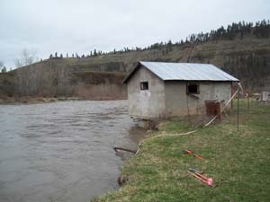 Well House Perched Over South Fork Clearwater River (September 2011): The removal or stabilization of the well house house bank will be part of the restoration plan.
 Bank Erosion Annual Loss (September 2011): Several feet of bank is lost annually on private lands along the South Fork Clearwater River. the mouth of Threemile Creek enters the South Fork Clearwater River across the river from this site and contributes to the instability. Lack of riparian vegetation along the banks are also a factor.
 Plantings Along Threemile Creek (October 2011): Local Grangeville elementary school students participated in planting activities along Threemile Creek, a main tributary of the South Fork Clearwater River. Students were able to walk to the site because of the close proximity of this in town restoration project.
 Students Learn About Restoration (October 2011): Local Grangeville elementary school students learn about the water cycle and enjoy fun and games outside before helping to plant the site with native trees and shrubs. This restoration project takes place on private property and is designed to help reduce sediment and temperature in Threemile Creek.
 High School Students Lead Planting Event (October 2011): Local Kooskia high school students lead elementary students in a day of planting. The students worked is small groups planting two restoration sites along the South Fork Clearwater River. Planting activities were designed to help stabilize the banks, reducing sediment and temperature in the South Fork Clearwater River.