
Watershed: South Fork Clearwater River
Stream Name: Threemile Creek
Date Established: 05/15/2006
Project Status: Complete; maintenance and monitoring underway
Overview
Funding Agency: Department of Environmental Quality
Project Location: Latitude 45.9761 N Longitude 116.0806 W
Target Pollutants:
- Sediment
- Temperature
- Nutrients
- Bacteria
Waterbody Type(s): Perennial
Hydrologic Unit Code: 17060305
Description
The South Fork Clearwater River (SF CWR) Riparian Restoration Project is designed under the guidance of the SF CWR Watershed Advisory Group (WAG) and the SF CWR Total Maximum Daily Load (TMDL), and represents activities identified in the SF CWR TMDL Implementation Plan. Restoration will reduce sediment and temperature, pollutants for which the TMDL on SF CWR was established, and will also reduce bacteria and nutrients, while improving riparian habitat. The restoration of a variable width buffer will provide shad and help to reduce extreme summer temperatures. Contributions of organic and woody material to the stream system will improve the structural complexity of the stream system, while also improving in-stream habitat for aquatic species.Riparian restoration activities on the Rylaarsdam property complement conservation measures being implemented by Idaho Soil and Water Conservation District. These activities include the removal of cattle from the riparian area and fencing. Additional work will include off stream watering.
Riparian restoration includes the sloping and stabilization of an estimated 2,800 feet of eroding stream bank, the re-development of an estimated 400 feet of low flow channel and the planting of an estimated 42,000 square feet of variable riparian buffer. Wetland swales will be included in the restoration design to provide additional filtration potential and increase flood water holding capacity.
Previous Conditions
According to the SF CWR TMDL, temperatures in excess of the water quality standards for beneficial use of cold-water aquatic life (19 C) and the more conservative salmon spawning criteria (9 C) are assumed to be the result of loading from the smaller headwater tributaries to the main stem system. In the Threemile Creek watershed, agriculture, grazing, urban development, and road construction activities have reduced vegetative cover and altered stream channel structure, resulting in bank instability and elevated summer water temperatures. Livestock grazing in the riparian area is also contributing to elevated bacteria and nutrients in Threemile Creek.
Photo History:
 Bank Before Excavation (April 2005): The steep eroded banks of Three Mile Creek. As stream banks like this slough off into the water, they deposit loads of sediment, contributing to pollution and decreasing biodiversity.
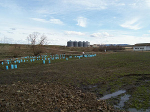
 Banks: Banks after resloping, remeandering, and with biologs and erosion control fabric.
 Excavation and Installation of Biologs: Ken places Biologs while the excavator follows behind, carving the slope of the bank into a gradual rise, as opposed to the steep erosion that had occurred before the restoration project began.
 Wetland Plants: To increase biodiversity, PCEI places wetland plants like these near or in streams. The varied root structures provided by a diverse mix of trees, shrubs, rushes, and sedges helps stabilize a streambank.
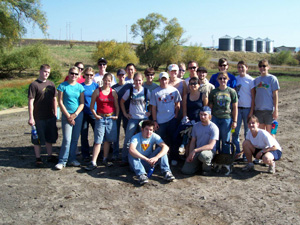 University of Idaho Students Help Out: On Saturday, September 30th, 30 volunteers from the University of Idaho travelled to the Three Mile Creek site in Grangeville and helped plant 175 trees and shrubs.
 UI Volunteers in Action: Two volunteers from the University of Idaho plant trees in an effort to revegetate the riparian are with native vegetation. Volunteer events like this one that occurred on Saturday, September 30th, 2006, are crucial to meeting project goals.
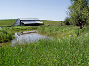
 Wetland! A newly created wetland on the project site filled with water just days after it was excavated. The fabric in the foreground will keep soil from eroding and washing downstream as water from the wetland spills over during high water. Later, many wetland plants were placed in the wetland, either submerged or planted close to the waterline.
 Culvert Before Restoration: This photo was taken in April of 2005 and shows the previous condition of the stream, close to where the wetland now is.
 Excavator Resloping Streambank: The excavator in action, sculpting the slope of the streambank.
 Excavator With Biolog: The excavator helps in placing biologs in the stream. The biologs are made of biodegradable fiber and help maintain the new slope and shape of the stream. Plants can easily grow around and even through them.
 Spring Tree planting! Volunteers and AmeriCorps members planted 350 plants along the wetland and stream banks in the spring of 2007.
 Lush Summer Vegetation: The vegetation has thrived at Threemile Creek! The native plants are doing well, but so are the weeds! The AmeriCorps watershed team along with volunteers have been spending many hours with weed maintenance.
 Plant Survival Counts: In early September the Watershed crew visited this site to water all the plants, mow down some of patches of weeds and perform a survival count of the plants. This dry, hot summer was a bit hard on the plants, but there is an overall survival rate of about 80%!